...

ELEPHANT DISTRIBUTION IN BANNERGHATTA FOREST

When the Elephant walk, forests walks with them

Manju Acharya

Mapping Elephants: Understanding Distribution and Challenges in Bannerghatta National Park This story map provides an in-depth look at Bannerghatta National Park, a crucial sanctuary for Karnataka’s iconic Asian elephants. Using dynamic maps and visuals, it explores the distribution of elephants, the unique habitat characteristics of this region, and the pressing challenges these gentle giants face. From habitat fragmentation and human-elephant conflict to the role of movement corridors, this narrative captures the critical interplay between ecological factors and human activities. By showcasing the current status and conservation priorities, this prototype demonstrates the importance of data-driven, landscape-level conservation planning to ensure a thriving future for one of India’s most cherished species.

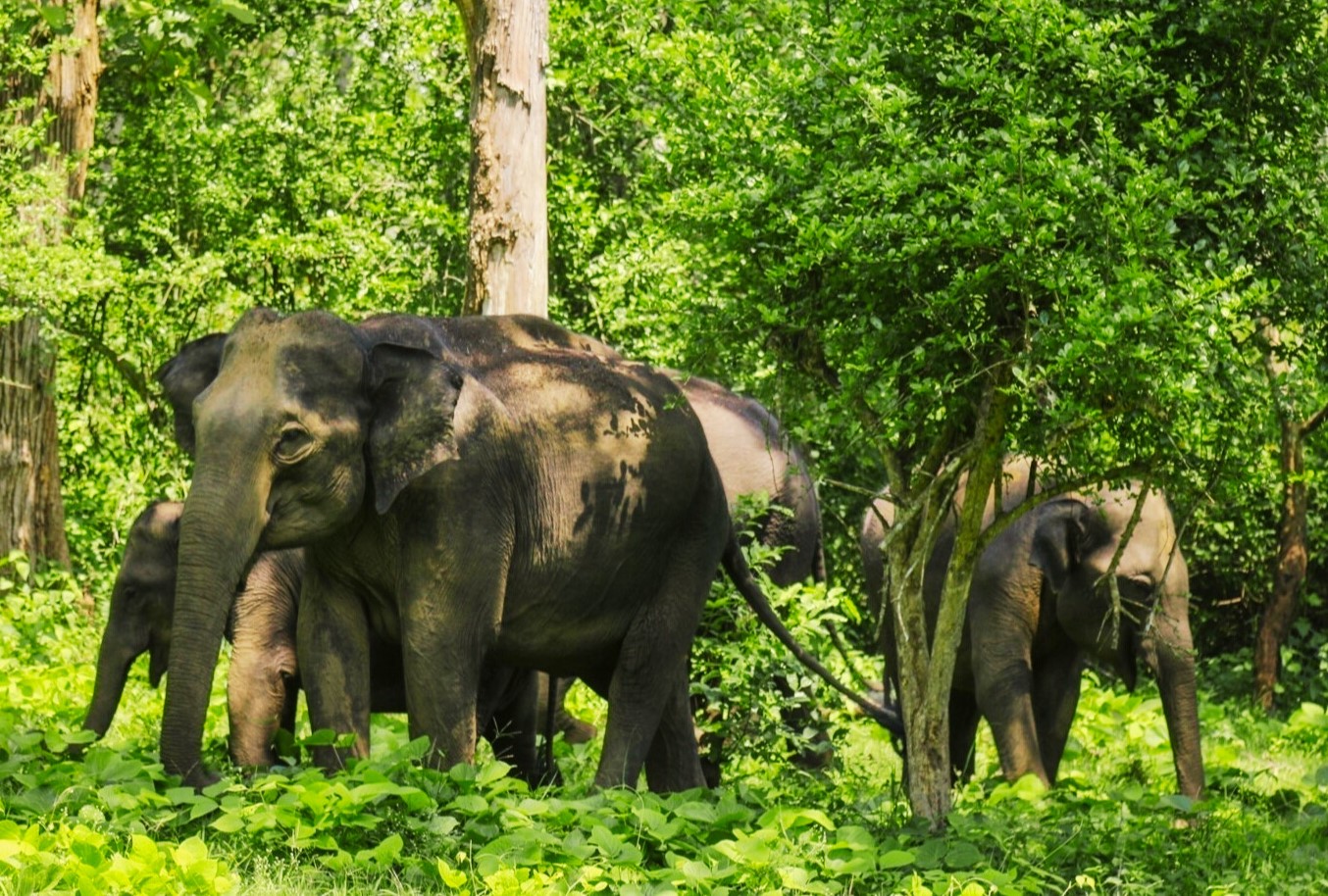
Elephant Distribution Areas (EDA) reveal patterns of habitat use by elephants, ranging from frequently to rarely used regions. These areas may include both expansive contiguous habitats and smaller, isolated patches, irrespective of the elephant density within them. Bannerghatta National Park serves as a critical example of this, where natural habitats, movement corridors, and anthropogenic influences converge.

"The forests are where the colors come alive, there are lots of hues and life in them as they are different but one entity"

This section delves into the ecological preferences that guide elephant habitat selection suitable vegetation, gentle terrain, and seasonal habitat connectivity and examines how developmental activities disrupt these critical patterns. Understanding EDA and mapping habitat links is essential for identifying key corridors and ensuring the long-term survival of these majestic animals in the face of growing human impacts.

Karnataka's forests cover about 20.11% of its land, ranging from the dense Western Ghats' evergreen forests to the dry deciduous and scrublands in the east. Major reserves like Bandipur, Nagarhole, and Bhadra support rich biodiversity and play a crucial role in climate regulation.

The state of Karnataka has an area of 1,91,791 km². There are a total of 51 forest divisions, out of which 34 have elephant distribution. These divisions cover 92,554 km², with elephants found in 11,801 km² (12.7% of the total area).

All forest divisions in Karnataka face the challenge of elephants leaving their natural habitat in search of crops. Only a few forest ranges are free from human habitation.

Lorem ipsum dolor sit amet consectetur adipisicing elit. Enim blanditiis dolorum eum officia quod? Nesciunt temporibus eligendi quo impedit deleniti.Some quick example text to build on the card title and make up the bulk of the card's content.

Lorem ipsum dolor sit amet consectetur adipisicing elit. Enim blanditiis dolorum eum officia quod? Nesciunt temporibus eligendi quo impedit deleniti.Some quick example text to build on the card title and make up the bulk of the card's content.

Bannerghatta National Park’s Role: The park serves as an ecological buffer, preserving genetic diversity among elephants and reducing human-wildlife conflict. Conservation strategies include habitat protection and community participation.

Elephant Density Mapping: Hexagonal density maps provide a visual representation of elephant distribution intensity in Bannerghatta National Park. These maps help in identifying high-movement zones and potential hotspots for human-elephant conflict mitigation.

Lorem ipsum dolor sit amet consectetur adipisicing elit. Enim blanditiis dolorum eum officia quod? Nesciunt temporibus eligendi quo impedit deleniti.Some quick example text to build on the card title and make up the bulk of the card's content.

Lorem ipsum dolor sit amet consectetur adipisicing elit. Enim blanditiis dolorum eum officia quod? Nesciunt temporibus eligendi quo impedit deleniti.Some quick example text to build on the card title and make up the bulk of the card's content.

Research in Bannerghatta National Park has identified areas with varying elephant densities using remote sensing and field surveys. The highest density regions correspond to seasonal migration routes and preferred feeding grounds.

These findings aid conservation efforts by prioritizing areas that require habitat protection, anti-poaching measures, and human-wildlife coexistence strategies.

Political Boundaries and Protected Areas: Bannerghatta National Park is situated across Bangalore Rural, Bangalore Urban, and Ramanagara districts, forming an ecological link between Karnataka and Tamil Nadu.

Geographical Features: The park spans an area of 103 km² with an undulating landscape, featuring hills and valleys. Elevations range from 720 m to 1025 m, providing diverse habitats for wildlife.

Climate and Hydrology: Bannerghatta National Park experiences a tropical climate with annual rainfall between 728 mm and 1352 mm, and an average temperature of 23.6°C. Several streams, including Antaragange Hole, Rayatmala Hole, and Amuthihalla, flow through the park.

Lorem ipsum dolor sit amet consectetur adipisicing elit. Enim blanditiis dolorum eum officia quod? Nesciunt temporibus eligendi quo impedit deleniti.Some quick example text to build on the card title and make up the bulk of the card's content.

Bannerghatta National Park (BNP) lies between 12°34’N to 12°50’N and 77°31’E to 77°38’E. Covering 103 km², it connects Ramnagara Forest Division to Hosur Forest Division in Tamil Nadu.

The park has five rural settlements within its boundaries, indicating agricultural influence. The climate is tropical, with annual rainfall between 728 mm and 1352 mm, and an average temperature of 23.6°C.

Key streams include Antaragange Hole, Rayatmala Hole, and Amuthihalla. Vegetation includes dry deciduous forests in the upper hills and scrub forests at the fringes. Mammals found here include elephants, Indian gaur, sambar, spotted deer, Indian pangolin, common leopard, wild dog, and sloth bear.

The park is occasionally visited by tigers from Cauvery Wildlife Sanctuary. Tribal communities such as Aadi Karnataka, Hakkipikki, Iruliga, and Lambani live within the park and engage in agriculture. BNP’s headquarters is located at Kalkere, Bangalore Urban district.

Topography and Elevation: Bannerghatta National Park has a rugged terrain with elevations ranging from 624 m to 1039 m above sea level. The topography plays a crucial role in defining elephant movement patterns and habitat distribution.

Elephant Distribution: Most elephant activity occurs between 700 m and 800 m elevation. These contours define the primary habitat zones where elephants find adequate food and water resources.

Challenges in Movement: Higher elevation areas with steep slopes restrict elephant movement, pushing them towards lower-lying regions. This concentration of movement in flatter areas often leads to human-elephant conflict in bordering villages.

Lorem ipsum dolor sit amet consectetur adipisicing elit. Enim blanditiis dolorum eum officia quod? Nesciunt temporibus eligendi quo impedit deleniti.Some quick example text to build on the card title and make up the bulk of the card's content.

Bannerghatta National Park features a varied topography crucial for elephant distribution. Studies show that elephants prefer mid-elevation zones due to available vegetation and seasonal water sources. The park’s altitude variations significantly impact wildlife movement and habitat selection.

Villages Reporting Elephant Visits: A total of 179 villages in Bannerghatta Wildlife Division report elephant visits, with 15 villages located inside the designated elephant distribution area.

Elephant Movement Beyond Habitat: The data indicates that elephants frequently move up to 2 km beyond their typical distribution areas, leading to increased interactions with human settlements.

Elephant Movement in Bannerghatta: Elephant visits in surrounding villages highlight the need for effective conflict mitigation strategies. Understanding movement patterns beyond designated habitats is crucial for developing conservation and community-based solutions.

In Bannerghatta Wildlife Division, 179 villages report elephant visits. Among them, 15 villages lie within the elephant distribution area. The remaining 164 villages report elephant visits outside the elephant distribution area. Beerasandra is the farthest from the nearest boundary of the elephant distribution located 1.8 km away. The finding indicates that the elephants move around 2 km beyond their distribution area.

Steep Slopes in BNP: Bannerghatta National Park features a maximum slope of 85.77 degrees. The terrain is rugged, influencing elephant movement and habitat selection.

Elephant Distribution and Slope: Within the elephant distribution area, slopes range between 30 to 85 degrees, with most regions experiencing slopes between 48 to 83 degrees.

Lorem ipsum dolor sit amet consectetur adipisicing elit. Enim blanditiis dolorum eum officia quod? Nesciunt temporibus eligendi quo impedit deleniti.Some quick example text to build on the card title and make up the bulk of the card's content.

Banerghatta NP has a maximum slope of 85.77 degrees. The slope in the elephant distribution area ranges between 30 to 85 degrees. Majority of the elephant distribution area has slope varying from 48 to 83 degrees. The terrain is rugged.

Extent of Elephant Distribution: The elephant distribution in Bannerghatta National Park covers an estimated area of 240.35 km², representing 86% of the total division.

Connectivity with Other Forest Divisions: The northern elephant distribution area shares a 20.7 km boundary with Bengaluru Urban Forest Division, while the southern part connects with Ramanagara Forest Division and Cauvery Wildlife Sanctuary through 15 km and 2 km boundaries, respectively.

Lorem ipsum dolor sit amet consectetur adipisicing elit. Enim blanditiis dolorum eum officia quod? Nesciunt temporibus eligendi quo impedit deleniti.Some quick example text to build on the card title and make up the bulk of the card's content.

The elephant distribution in the Bannerghatta National Park is spread continuously across the division over an area of 240.35 km2, which is estimated to be 86% of the total division. All the four ranges have elephant distribution and elephants are distributed in the 22 forest beats of the National Park. Some patches in the northern part of the elephant distribution area are connected to the elephant distribution of the Bengaluru Urban FD through a shared boundary of 20.7 km. The southern part of the elephant distribution is connected to both Ramanagara FD and Cauvery Wildlife Sanctuary through a shared boundary of 15 km and 2 km respectively.

Elephant Visit Frequency: The frequency of elephant visits in Bannerghatta National Park varies seasonally, with peaks observed in dry months when water sources are scarce.

Data Trends: Analysis of historical data indicates certain hotspots where elephants frequently traverse, aiding in better management and mitigation strategies.

Impact on Local Communities: Frequent elephant visits to agricultural lands lead to significant crop damage, emphasizing the need for mitigation measures such as early warning systems and buffer zones.

Lorem ipsum dolor sit amet consectetur adipisicing elit. Enim blanditiis dolorum eum officia quod? Nesciunt temporibus eligendi quo impedit deleniti.Some quick example text to build on the card title and make up the bulk of the card's content.

Understanding Elephant Frequency: By mapping the frequency of elephant visits, researchers can identify critical areas requiring enhanced conservation efforts and preventive measures to mitigate human-elephant conflict.

Studies show that elephants tend to revisit certain locations due to the availability of food and water, making these areas prone to conflict. Conservation efforts are focused on habitat restoration, natural corridor maintenance, and community awareness programs to reduce interactions between humans and elephants.

Predictive modeling based on frequency data helps in designing wildlife-friendly infrastructure and guiding policy decisions for sustainable coexistence.

Heatmap Analysis: The heatmap visualizes high-density elephant activity zones, highlighting migration corridors, feeding areas, and human-elephant conflict zones.

Significance of Hotspots: Areas with high elephant density often coincide with vital resources like water bodies and forest patches, making them key conservation focus zones.

Conservation Applications: Heatmaps aid in proactive planning, helping authorities allocate resources for conflict mitigation and habitat conservation efforts.

Understanding Heatmap Insights: Heatmaps are crucial for identifying elephant hotspots within Bannerghatta National Park. These maps highlight regions where elephants frequently congregate, offering valuable insights into habitat preferences and movement patterns.

The analysis reveals seasonal variations in elephant density, with peak activity observed near perennial water sources and preferred grazing areas. Additionally, human-elephant conflict zones emerge where migration paths intersect with human settlements, necessitating strategic interventions.

Conservationists use heatmaps to design buffer zones, develop eco-friendly agricultural policies, and improve awareness programs, ensuring sustainable coexistence between wildlife and communities.